
MIPAS helps to validate ozone predictions by Chemistry-Climate Models
MIPAS observations of ozone in the mid-latitude upper troposphere / lower stratosphere region has been used to validate chemistry-climate models.
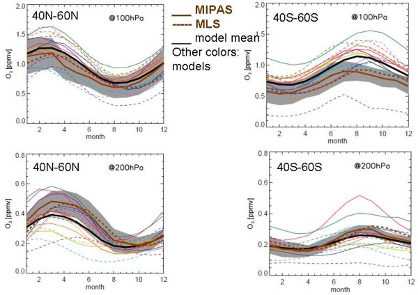
Ozone in the tropopause region (around 10 to 18 km or 300 to 70 hPa) is one of the major drivers of the Earth's radiation budget. Its relevance for climate change is the reason that climate models need to predict correctly the ozone distributions in the tropopause region and their future development. Within the WCRP-SPARC initiative CCMVal (Chemistry-Climate Model Validation Activity for SPARC) the ozone distribution as produced by a suite of chemistry-climate models world-wide has been compared to real distributions of ozone in the tropopause region obtained from the satellite instruments MIPAS and Aura/MLS.
The figures show the seasonal cycle of ozone at 100 and 200 hPa for the Northern and Southern mid-latitudes. The brown lines are satellite measurements (solid: MIPAS; dashed: MLS), while the black solid curve is the model mean, and the colored lines are the results of individual models. The shaded area is the measurement uncertainty. Most models perform reasonably well for ozone in the NH, however the amplitude is consistently too high at 100 hPa and too low at 200 hPa. The latter finding indicates that the models exhibit too much transport from the tropics at and above 100 hPa, and across the tropopause at 200 hPa.
The CCMVal comparison results will be used to further improve chemistry-climate models.
For more information see: http://www.agu.org/pubs/crossref/2010/2010JD013884.shtmlSPARC CCMVal Report online: http://www.atmosp.physics.utoronto.ca/SPARC/ccmval_final/index.php