
Influence of the Indian Summer Monsoon on Water vapor and ozone concentrations in the tropopause region
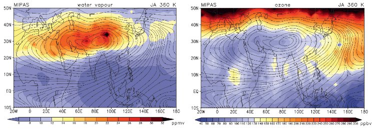
The figure shows the multi-annual mean of the water vapor (left) and ozone (right) distribution at
The MIPAS observational data have been used to validate the representation of the Indian summer monsoon circulation in some current chemistry climate models. The main assessment focuses on the anticyclone that forms in the upper troposphere and lower stratosphere and the related changes in water vapor and ozone during July and August for the recent past. Current CCMs capture the average synoptic structure of the Indian Summer Monsoon anticyclone well. The associated impact on water vapor and ozone in the upper troposphere and lower stratosphere as observed with MIPAS-Envisat is captured by most models to some degree. Nevertheless, the strength and position of the Indian summer monsoon anticyclone differ considerably.
In a future climate the models indicate that the used monsoon activity index weakens slightly, which leads to a relative lower and warmer tropopause. Water vapor is predicted to increase in the anticyclone most strongly at
For further details see: http://journals.ametsoc.org/doi/abs/10.1175/2010JCLI3280.1