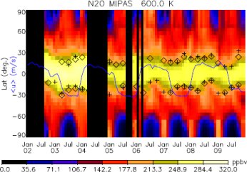
The subtropical transport barrier restricts air exchange between the
tropical and the mid-latitudinal stratosphere and is the boundary of the
"tropical pipe" in which air is uplifted by the Brewer-Dobson
circulation. The left Figure shows the mixing ratios of N
2O from MIPAS
observations at the 600 K potential temperature level (about 25 km
altitude). Already this figures gives an impression of the strong
meridional gradient in N
2O caused by restricted mixing (yellow to orange). The symbols give the position of the mixing barrier as assessed in this study. It can be shown that the meridional gradients in tracer
distributions are strongest where the probability density distributions
(pdfs) have their minima. The position of the subtropical mixing
barrier determined by searching the minima in tracer pdfs is shown in
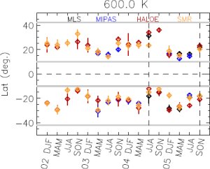
the right figure. N
2O from the instruments MIPAS, MLS, and SMR, and
methane from HALOE have been used for this assessment. The four
instruments show consistently a strong variation of the subtropical
mixing barrier positions with seasons, being furthest north in boreal
summer and furthest south in boreal winter. The longer time series from
HALOE reveals an overlaid variation with the QBO cycle, too.
For further details see
http://www.atmos-chem-phys.net/11/10579/2011/acp-11-10579-2011.html
