
MIPAS detects pollutants in the upper troposphere
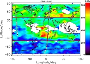
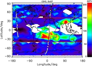
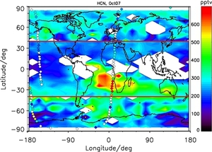
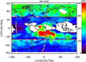
Maps of pollutants in the upper troposphere in October 2007 as measured by MIPAS: C2H6 (top left), C2H2 (top right), HCN (bottom left) and PAN (bottom right). At low latitudes (between plus/minus 40 degrees the altitude is 12 km, at higher latitudes it is 8 km. A large biomass burning plume is clearly visible. Maps of pollutants in the upper troposphere in October 2007 as measured by MIPAS: C2H6 (top left), C2H2 (top right), HCN (bottom left) and PAN (bottom right). At low latitudes (between plus/minus 40 degrees the altitude is 12 km, at higher latitudes it is 8 km. A large biomass burning plume is clearly visible.
Biomass burning products and products of other sources of air pollution have already been observed by MIPAS from 2002-2004, when the instrument measured at high spectral resolution. After a failure of the interferometer slide in 2004, the spectral resolution was degraded substantially, making analysis of minor contributors to the infrared spectrum more difficult. Meanwhile distributions of atmospheric pollutants are successfully retrieved also from the reduced spectral resolution measurements. For details, see http://www.atmos-meas-tech.net/5/723/2012/amt-5-723-2012.html